Open the latest version of Google Earth, switch to "Mars" and search for "Meliza". Click on the small robotic icon and you'll be able to chat with Meliza, a friendly relative of Eliza, one of the first chat bots. A message informs Earthlings that "Meliza is using an account on a different planet. There may be translation errors." The chat bot has some predefined text related to Mars and it can't answer to many questions, but it's always ready to rephrase your messages.
Here's Meliza's first message: "Greetings, Earthling! What do you think of Google Mars?Have you checked out Valles Marineris? It's like the Grand Canyon, but bigger. Mars is so much better than Earth!"
In other news, Google and NASA sponsor Singularity University. "In 2005, futurist Ray Kurzweil published The Singularity Is Near, a comfort-rattling forecast of a few decades hence when artificial intelligence will overtake human capability and an array of other huge leaps will fundamentally alter our lives. Now, Kurzweil is helping to launch a university rooted in the book's predictions. In June, Singularity University is scheduled to open with a faculty replete with scientific celebrities, and an initial class of 30 students at NASA's Ames Research Center in Silicon Valley."
Google Earth 5, the latest version of Google's 3D geo-browser, brings an important feature from the discontinued Google Earth Plus, which used to cost $20/year. You can now read tracks and waypoints from a GPS device like Magellan and Garmin and you can import GPS files in GPX and LOC format.
Another interesting new feature is the ability to visualize geographical changes over time. Google Earth shows historical imagery that goes back to the 40s in some places like San Francisco.
If you find an interesting way to visualize a location, there's a new "record a tour" option that saves the places you visit in Google Earth and lets you replay the tour. Unfortunately, you can't export a tour in a video format using the free version of Google Earth, but the good news is that you can record a voice commentary.
Google Earth is no longer just about the Earth and stars, now you can use it to view imagery and terrain of Mars by clicking on the planet icon.
While all these additions useful, you'll most likely download Google Earth 5 to explore the ocean. "Dive beneath the surface and visit the deepest part of the ocean, the Mariana Trench. Explore the ocean with top marine experts including National Geographic and BBC. Learn about ocean observations, climate change, and endangered species. Discover new places including surf, dive, and travel hot spots and shipwrecks."
Google Earth 5 for Windows, Linux and Mac can be downloaded from earth.google.com. The Windows version is not download directly: you first install Google Update, which downloads the setup and then installs the application. For those who can't use Google Update, here's a direct link to the Windows client.
Tip: Before installing Google Earth, read the user guide.
The first desktop application ported by Google to a mobile phone is Google Earth. iPhone and iPod Touch users can download for free from the App Store the best way to explore satellite imagery in 3D.
"Not only is having Google Earth on your iPhone convenient, but the touch interface is a very natural way to interact with the Earth. Just swipe your finger across the screen and you fly to the other side of the globe; tilt your phone and your view tilts as well. You can pinch to zoom in or out, or just double tap with one finger to zoom in and two fingers to zoom out," says Google LatLong Blog.
CNet writes that iPhone's multitouch makes the experience much more intuitive than in the desktop version of Google Earth. Like Google Maps for Mobile, the application can detect your location using information from GPS, Wi-Fi networks, and mobile phone towers. You can explore interesting places and discover more about them using the integrated layers: Wikipedia and Panoramio photos.
The cool applications that were only available from your computer start to be ported to mobile phones. In the future, the most exciting applications will be first launched for mobile phones.
Google Earth can now be used from a browser, without having to install the full application. Instead of the application, you need to install a plug-in that only works in Firefox and Internet Explorer 6/7 on Windows.
Google also launched an JavaScript API that lets you interact with the globe, draw markers, add layers or integrate with Google Maps. "The Google Earth Plug-in and its APIs let you embed the full power of Google Earth and its 3D rendering capabilities into your web pages." Google LatLong blog announced that each Google Maps mashup can take advantage of the new 3D view by adding a single line of code. "Our goal is to open up the entire core of Google Earth to developers in the hopes that you'll build the next great geo-based 3D application, and change how we view the world."
The samples look pretty promising, but I find it hard to understand why Google didn't use the API to create a better experience and bring more features from Google Earth (the search box, the list of overlays, the navigation controls) in a single interface.
Before downloading the plugin, please note that Google installs it in Firefox and Internet Explorer, along with a system service called "Google Update Service". The plug-in uses a lot of memory (around 100 MB just for loading the initial view and 300 MB for the Monster Milktruck demo) and, for each embedded object, you're running an instance of the Google Earth application.
There's a new layer for Google Earth that shows Google News stories related to a location. At the recent "Factory Tour of Search" event, Google explained the difficulties of automatically identifying the locations of a news story. For example, just because a news article includes "Paris" doesn't mean that the article talks about France's capital. It could be about the Texas city or Paris Hilton, so the algorithm needs to disambiguate names, identify complete addresses and determine the importance of an alleged location in a text. Google News also uses its automatically-generated clusters to validate locations and their importance to a news story.
"The launch of Google News on Google Earth is a milestone in the evolution of the geobrowser. By spatially locating the Google News' constantly updating index of stories from more than 4,500 news sources, Google Earth now shows an ever-changing world of human activity as chronicled by reporters worldwide. Zoom into areas of personal interest and peruse headlines of national, regional and, when fully zoomed in, even the most local of interest," says Brandon Badger, Product Manager of Google's Geo team.
To enable the Google Earth layer, go to the Layers sidebar, expand "Gallery" and select "Google News" from the impressive list of overlays. Another news-related layer that has been recently added to Google Earth is for New York Times, but it's likely that the news are geo-coded manually.
If you want to read news related to a location in your browser, add a local section to the personalized Google News homepage. "Adding a Local News section allows you to track news stories from and about a particular city or region. While this function is currently only available in our English language editions, we hope to add more languages and regions in the near future," explains the Google News help center.
The latest version of Google Earth brings a lot of interface changes and new features. There's a redesigned and improved navigation control that lets you change the perspective much faster. Here's the description from Google Earth's help center:
"1. Click the north up button to reset the view so that north is at the top of the screen. Click and drag the ring to rotate your view. 2. Use the Look joystick to look around from a single vantage point, as if you were turning your head. Click an arrow to look in that direction or continue to press down on the mouse button to change your view. After clicking an arrow, move the mouse around on the joystick to change the direction of motion. 3. Use the Move joystick to move your position from one place to another. Click an arrow to look in that direction or continue to press down on the mouse button to change your view. After clicking an arrow, move the mouse around on the joystick to change the direction of motion. 4. Use the zoom slider to zoom in or out (+ to zoom in, - to zoom out) or click the icons at the end of the slider. As you move closer to the ground, Google Earth swoops (tilts) to change your viewing angle to be parallel to the Earth's surface. You can turn off this automatic tilt (Tools > Options > Navigation > Navigation controls; Mac: Google Earth > Preferences > Navigation > Navigation controls)."
You can now display the sun by enabling View > Sun or clicking on the sun button from the toolbar. To create time-lapse views of sunsets and sunrises, click on the "play" button and watch the changes.
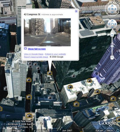
For some of the imagery, you can see at the bottom of the window an approximation of the date when it was taken. The Street View images from Google Maps are now available in a new Google Earth layer, which is not enabled by default.
Google Earth includes much more models in the 3D buildings layer for cities like: San Francisco, Boston, Orlando, Munich, Zurich. "Google has optimized the loading and performance of 3D buildings. When you first turn on the 3D Buildings layer near a city with models, you'll see simplistic versions of the buildings load up really fast, then they gradually get more solid and load more texture detail," explains the unofficial Google Earth Blog.
Google Earth 4.3 can be downloaded from earth.google.com. Windows users that don't want to install the application using Google Updater can try this direct link. You'll probably notice that the Windows setup is much smaller: the size has been reduced from 12.7 MB to 7.36 MB. Unfortunately, the new version seems to be less stable and it uses more resources, but it's still in beta.


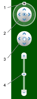 "1. Click the north up button to reset the view so that north is at the top of the screen. Click and drag the ring to rotate your view.